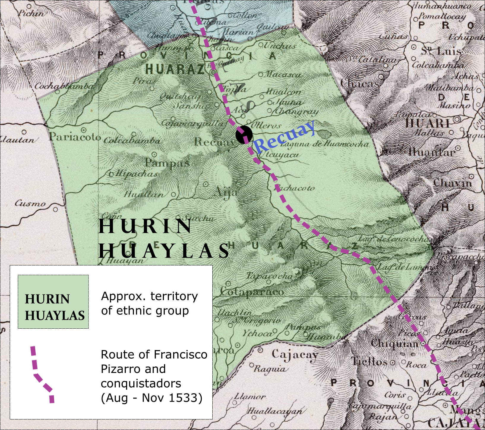
Machu Picchu

Mapping Conquest

A Spatial History of the Spanish Invasion of Indigenous Peru (ca. 1528-1537)

Mapping Conquest

What role did Indigenous actors play in the Spanish ‘conquest’ of Peru?
How were these foreign invasions affected by local Indigenous history and geography?

To answer these questions, this work combines ethnohistorical, digital history, and geospatial methodologies to retell the story of the Spanish invasion of Peru (and of European conquests of Indigenous societies more generally).

This study integrates these methods – as well as lessons from similar interdisciplinary fields such as literary geography and Historical GIS – into a new two-step methodology. This methodology:

  1. deconstructs colonial texts and traces how they conceal Indigenous activity and presence, and
  2. reconstructs the role of previously erased or marginalized Indigenous people, places, institutions, and histories.

For the conquest of Peru, the resulting analysis contributes to other scholarship examining the key role of Indigenous allies and auxiliaries in shaping the events of the conquest era. Unlike previous research - which is largely anecdotal - this study systematically reconstructs the ubiquity and magnitude of this aid and participation. Moreover, it shows Andean allies invited, guided, accompanied, and fought alongside the conquistadors not as passive subordinates but as political actors pursuing their own agenda.

Telling stories with Maps and Visualizations

Comparing Spanish and Andean perspectives of the conquistadors' 1533 passage through the region of Huaylas.

Mapping the Invaders' Perspective

Ghost Landscapes in Pedro Sancho's narration of the 1533 Spanish invasion of the Central Andes (in Sancho's 1534 *Relación*)

Visually maps Spanish eyewitness authors' limited knowledge of, understanding, and recording of Andean landscapes

Full image

Visualizing Hidden Topographies

Reconstructing the Callejón (Alley) of Huaylas

Uses data from the Shuttle Radar Topography Mission to build a 3D model of landscapes in QGIS, and then overlying that topography with historical detail.

Full image

Terra incognita et invicta

Mapping the divide between the known and unknown

Approximating the limits of the Spaniards' sight and knowledge of the territory of the Huaylas

Full Image

Surpressed Experiences

Incorporating unpublished testimony describing events suppressed by accounts for public audiences

Spanish eyewitness testified in litigation to being welcomed into the town of Hatun Huaylas by a powerful female leader or kuraka. Authors writing for royal or public audiences, however, say nothing of the welcome and hospitality provided by the Huaylas people.

Full Image

Longer-Term Indigenous Histories

Contextualizing the events of 1533 within longer-term regional Andean histories

Reviewing the history of the region of Huaylas and the alliance they formed with the Spaniards helps explain the Huaylas' actions in 1533.

Full image

Indigenous perspectives

Reconstructing Andean presence in the invasion caravan of 1533

Testimony by Chachapoyas people four decades after their invasion recall an ancestor of theirs traveling with the caravan until the Callejón de Huaylas.

Full image

Typical Maps of Conquest

The typical map of the Spanish conquest of Peru - found in many books on the topic - traces the route of Francisco Pizarro from his first explorations of the coast to his march through Inka Peru, ending with his arrival in the imperial capital of Cusco (1531-1533). The problem with this map is that it suggests the Spanish invaded a blank and people-less landscape. Like most European eyewitness texts, these maps erase the presence and agency of Indigenous people.

Mapping Indigenous Territory

This project, among other things, seeks to place Indigenous people back on the map. The simplest way to do this is to include approximations of Indigenous territory. Here, Pizarro's 1533 invasion of Peru is laid over not a map of blank Andean territory, but a cartographic approximation of the territory occupied and controlled by the Hurin Huaylas ethnic polity. Unlike previous maps of the Pizarro invasion, this one makes clear the conquistadors were entering Indigenous territory with a history.1

Mapping the Limits of the Imperial Gaze

In 1534, Spaniards occupied just three towns in all of the Andes. Yet, various Spanish authors claimed their conquest of Peru to be complete. Mapping the limits of Spanish presence and knowledge reveals how deceiving such claims were.

Mapping Experiences

as Heidi Scott has argued, the Spaniards' “physical engagements with landscape, and consequently their portrayals of it, were strongly shaped by the agency of Indigenous groups and by their physical presence or absence.”1.5 Interestingly, the fields of literary geography and affective cartography provide a means to test this argument. Click on the image to the left to see how I apply affective or emotional cartographic techniques to demonstrate the link between the availability of Indigenous labor and the experiences of the conquistadors during their initial explorations along the coast.

Mapping Movement

For some time, ethnohistorians have, of course, been mapping the location and territories of Indigenous groups. However, this tendency to map ethnic territory often provides the misleading impression of stasis even when the accompanying text more carefully describes communities under constant flux and historical change.

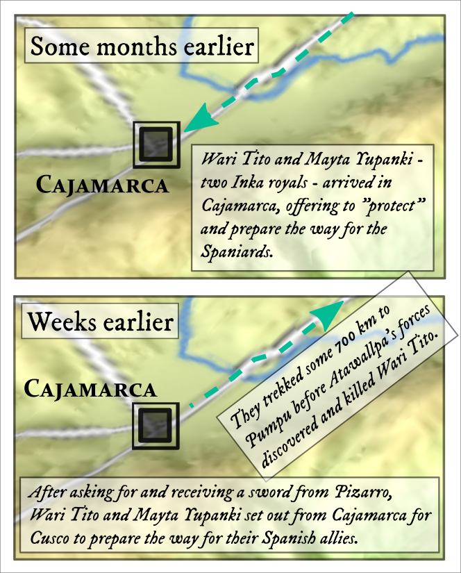
For a history of events, such as the events of the conquest-era, the activity and movement of Indigenous 
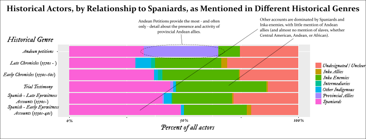
people has remained sorely understudied. In particular, while many scholars have shown how much colonial texts conceal Indigenous agency, there is still a need to systematically reconstruct this activity as a means to uncover the dynamism of Indigenous America during the era of European contact and conquest.

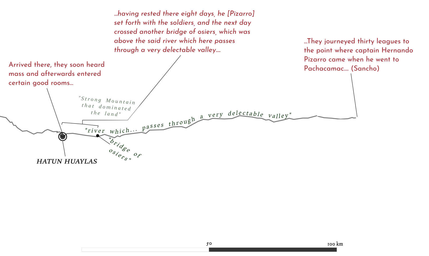
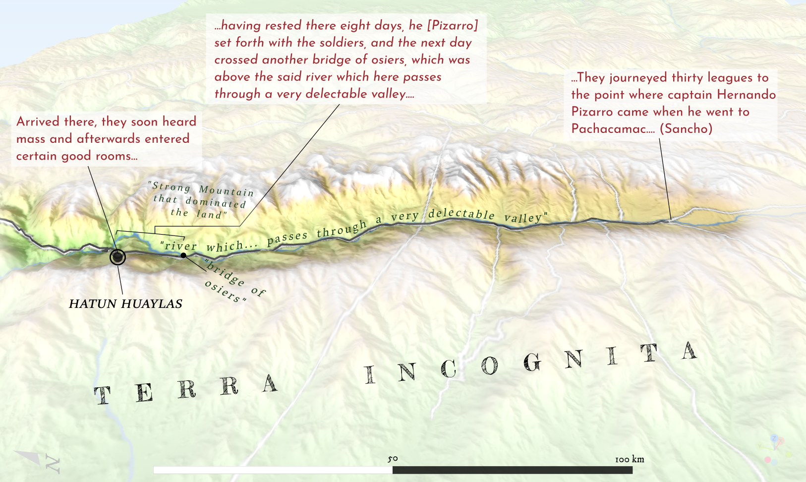
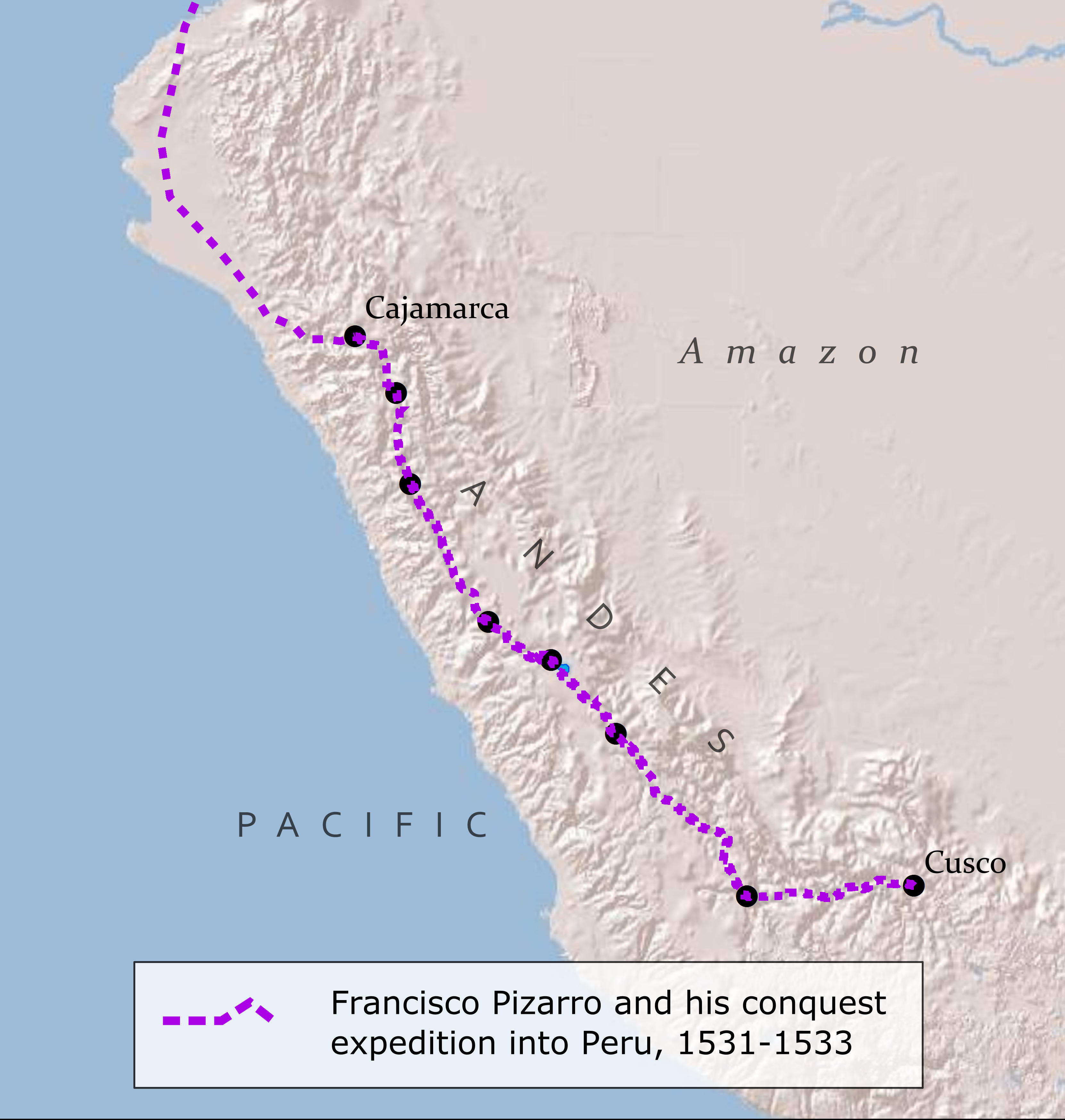
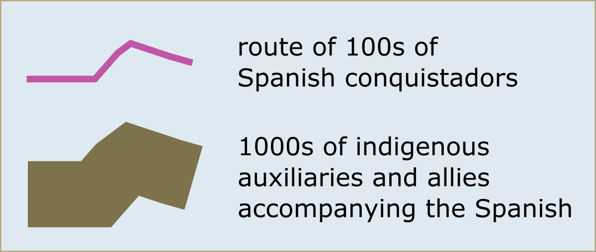
This study moves past European explanations to analyze and map Indigenous activity recorded in European and Indigenous texts. Whereas colonial texts may focus almost entirely on the activity of a few Europeans – only dropping a few hints to the movement and activity of much larger groups of Indigenous people, the maps produced here allow the visual comparison of the magnitude of such activity. Thick lines, representing the marches of Indigenous armies numbering in the tens of thousands, dwarf narrow lines symbolizing the movements of small bands of conquistadors.

Mapping Indigenous Activity

Historians have long argued that to understand Indigenous encounters with European invaders and settlers tracing Indigenous activity often explains far more than trusting European explanations. Charting the Andeans traveling to and from Cajamarca in 1532 and 33, for example, explains the degree to which the subsequent Spanish travel through the Inka heartland was shaped by Andean agency.

Visualizing Silences in Texts

The most commonly cited and read texts in studies of the invasion of Peru center Spanish conquistadors and the Inka resistance. Surviving evidence of the actions of provincial Andean and Inka allies, however, is preserved in petitions and testimony from Andean communities.

WORK IN PROGRESS...